Paddling in White Springs
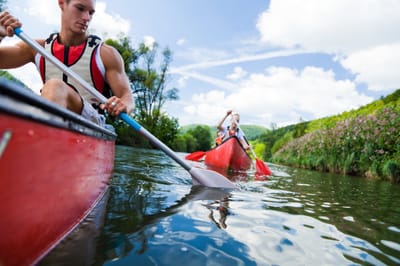
White Springs is nestled around the Suwannee River, twenty five miles from the headwaters in the Okefenokee Swamp in Georgia. The Suwannee is a black water river, rich in tannins from the Cypress trees in the swamp and along the banks. The longest river in the United States without a dam, the river height varies as the amount of rainfall in the swamp, by 30 feet or more. The Suwannee River Water Management District maintains several boat ramps along the river for easy access and varying length paddles. They also maintain river camps for overnight paddles.
Click here for more information about the Suwannee River Wilderness Trail and the River Camps.
Click here for American Canoe Adventures in White Springs for Canoe and Kayak rentals and shuttles.
Click here for more information about the Suwannee River Wilderness Trail and the River Camps.
Click here for American Canoe Adventures in White Springs for Canoe and Kayak rentals and shuttles.
Suwannee River
Roline Tract (mile 202)
From White Springs, travel north on CR 135 about 15 miles, cross over County Road 6, continue north on Woodpecker Road 2 miles, then turn right on NE 38th Trail to the parking area and ramp.
Turner Tract (mile 198)
From White Springs, travel north on CR135 about 15 miles, cross over County Road 6, continue north on Woodpecker Road about a mile, then turn right on NE 25th Way to the parking area and ramp.
County Road 6 (mile 196)
From White Springs, travel north on CR135 about 15 miles, then turn right on County Road 6 for a mile, then follow the double track dirt path parallel to CR 6 as it approaches the river. The is space to park as you near the river.
Cone Bridge Rd (mile 187)
From White Springs, travel south about 3 miles on US 41 to Lassie Black Road, then turn left on US 441 after about 5 miles, then turn left on Cone Bridge Road after 8 miles, to the parking area and ramp.
Big Shoals (mile 177)
From White Springs, travel north on CR135 a few miles, turn right on SE 94th St, to the parking area in Big Shoals State Park.
Wayside Park (mile 171)
From White Springs, travel south about 2 miles on US 41 to Wayside Park. This is also one of the ends of the Bridge To Bridge mountain bike trail.
Stephen Foster Folk Culture Center State Park (mile 168)
From White Springs, travel north on US 41 to the bottom of the hill, then follow the signs in the park to the boat ramp.
Blue Sink (mile 163)
From White Springs, travel south about 3 miles on Hwy 136 to 27th Road, turn right and the access is about 3 miles down the road. Note that this take-out will be on the LEFT side of the river.
Swift Creek (mile 163)
From White Springs, travel west about 3 miles on CR 25A to the Swift Creek Tract sign, turn left and follow the doubletrack to a dirt parking lot. Note that this take-out will be on the RIGHT side of the river, a little past Blue Sink on the other bank. Also note that there is not a boat ramp here, just a sandy bank. It is recommended that you make yourself familiar with this takeout point before getting on the river.
Rocky Creek (mile 163)
From White Springs, travel south about 4 miles on Hwy 136 to Hwy 136A, turn right and continue less than a mile 53rd Road. Turn right and after almost 2 miles the road turns left and becomes 60th Place. Limited parking is available at the end of the road.
Woods Ferry (mile 158)
From White Springs, travel south about 4 miles on Hwy 136 to Hwy 136A, turn right and after 3 miles turn right on 57th Drive. The entrance to the tract is about a mile down the road.
Suwannee Springs (mile 150)
Head north from White Springs on US 41 to CR 132, turn left, and then left on US 129 to Suwannee Springs.
Withlacoochee River
SR 6 Bridge Madison Blue Springs (mile 12)
Take FL 136 W to I-75 N to exit 460. Keep left, follow signs to Madison, turn left on FL 6 W to Madison Blue Spring State Park.
Suwannee River State Park
The Withlacoochee River flows into the Suwannee River at Suwannee River State Park, requiring a 100 yard paddle upstream to the park's boat ramp. To get there, take FL 136 W to CR 136A to its end. Turn left on US 129 to I 10W to exit 275, US 90 W to the park.
nearby Lakes
Eagle Lake
Eagle Lake is 11 miles NW of White Springs, created from phosphate mining, and is home to a variety of fish and birds and alligators. To get to the boat ramp take US 41 N out of town 3 miles to the blinking light and turn right on SE CR 137, then 3 miles later turn left on SE 78th Place. A half mile after that take the first right, and right again after the railroad tracks.
Peacock Lake
Take FL 136 W for 9 miles, then turn left on CR 417 to US 90. Turn right on 90 and then left on 75th Drive and then right on 75th Place to the boat ramp.
Alligator Lake
Alligator Lake in Lake City has a launch area for canoes or kayaks into the surrounding wetlands. From White Springs take US 41 S to US 90 in Lake City, then head East for 2 miles then turn right on S Avalon Ave.